APRIL 2019, MAY 2019, MAY 2020, APRIL 2021, MARCH 2022 & APRIL 2025
 |
| GOODING CITY OF ROCKS |
 |
| GOODING CITY OF ROCKS |
 |
| GOODING CITY OF ROCKS |
 |
| GOODING CITY OF ROCKS |
 |
| GOODING CITY OF ROCKS |
 |
| GOODING CITY OF ROCKS |
 |
| GOODING CITY OF ROCKS |
 |
| GOODING CITY OF ROCKS |
 |
| GOODING CITY OF ROCKS |
 |
| GOODING CITY OF ROCKS |
 |
| GOODING CITY OF ROCKS |
 |
| GOODING CITY OF ROCKS |
 |
| GOODING CITY OF ROCKS |
 |
| GOODING CITY OF ROCKS |
 |
| GOODING CITY OF ROCKS |
 |
| GOODING CITY OF ROCKS |
 |
| GOODING CITY OF ROCKS |
 |
| GOODING CITY OF ROCKS |
 |
| GOODING CITY OF ROCKS |
 |
| GOODING CITY OF ROCKS |
 |
| GOODING CITY OF ROCKS |
 |
| GOODING CITY OF ROCKS |
 |
| GOODING CITY OF ROCKS |
 |
| GOODING CITY OF ROCKS |
 |
| GOODING CITY OF ROCKS |
 |
| GOODING CITY OF ROCKS |
 |
| GOODING CITY OF ROCKS |
 |
| GOODING CITY OF ROCKS MAP |
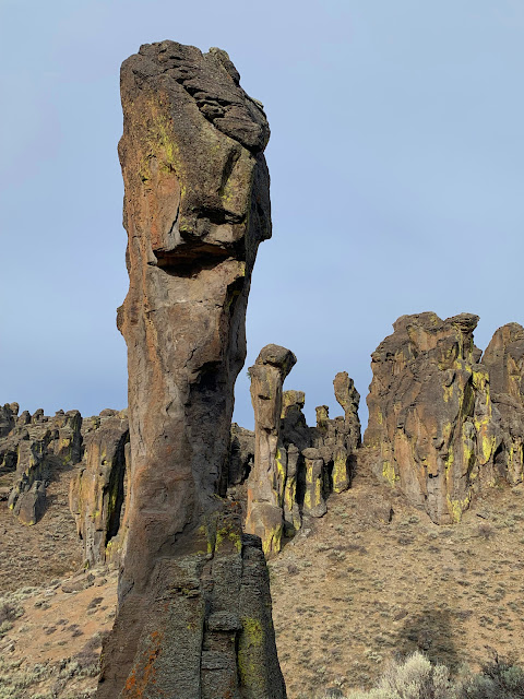
The Gooding City of Rocks (not to be confused with the nearby Little City of Rocks) is my kind of place. It includes some incredible canyons and rock formations, yet remains mostly unknown. I just found out about it a couple years ago, and almost nobody I talk to in Boise has ever heard of it. The best time of year to visit is likely May, as there will be a lot of greenery and streams will be running strongly through most of the major canyons. Be aware that it is located at a fairly high elevation, so the road into it may not open until around May. I originally tried to hike it in March of 2019, only to find the road covered in a foot of snow.
The Gooding City of Rocks includes a labyrinth of canyons. The first time I visited in April of 2019, I hiked two of the smaller canyons to the southeast and was blown away by what I saw. I had picked out two of the larger canyons to hike prior to arriving, but ended up switching things up when I saw how green and pleasant the first canyon I arrived at was. I just started following the stream running through the canyon just below the parking area until I came to the next canyon with a strong stream and decided to follow it up and back to my car.
Being so impressed with my first visit, I returned again in May to try the more common loop starting at Coyote Springs. This area was even more impressive than the first area I visited. The trail was a bit rough at the start, trying to decide whether to stay above, or slog through the water and tall grasses along the stream. I did a mix of both before the canyon eventually opened up and the walking became easier. Both times I visited I had the entire place to myself, which made me a little nervous. The rocks in these canyons formed in a way which created numerous dark caves, which would make perfect homes for coyotes, mountain lions or bears. I never saw one, but always tried to stay as far away as I could just in case. I did see a couple deer carcasses along my walk that made me a bit nervous in some parts. But all in all, a very pleasant place to spend an afternoon. There are also supposed to be some petroglyphs just east of the main road that I have so far been unable to find. It's hard to believe this area is still flying under the radar.
I returned to the Gooding City of Rocks again in May, 2020 to explore Coyote Creek, the canyon to the west of where I hiked previously, as it looked really impressive from aerial maps. I got off to a slow start however, as I got a bit off course and ended up hiking down the wrong canyon for a while. Eventually I realized my mistake and made a long cross-country trek back to Coyote Creek where I found a spot to drop down into it. While Coyote Creek is beautiful, it is very difficult to move around in. The spot I dropped into was completely overgrown with trees, shrubs and bushes that made it very difficult to move through. I found myself thinking this canyon would be the perfect spot for a trail, due to how lush and shady it was. I was impressed with all of the birch trees located this far out into the desert, and Coyote Creek is a fairly large stream with fish in it, though it did keep disappearing underground like a lot of streams in the Gooding City of Rocks do.
I visited again in April of 2021 hoping to check out some of the canyons to the west of the main loop, and it ended up requiring a lot more effort than I had anticipated. I first made my way into and out of Coyote Creek, which didn't require too much effort, but the next canyon was much deeper, and took a lot of work to get to the bottom of and climb back out again. Though it did have a large healthy stream with fish running through it. I originally planned to explore some of the canyons beyond here, due to how pleasant they looked in aerial photos, but I was so exhausted from the hike over, that I didn't quite reach my planned destination. I actually found an elk carcass in one of the canyon I was following, and thought I heard a group of coyotes yelping nearby just before deciding to head back.
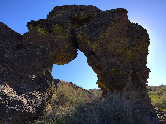
I hiked south for a mile or so before finding another way into the deep canyon, and walked up a pleasant side canyon feeding into it which had a nice stream running through it. I then worked my way over and down into Coyote Creek, near the location where I had entered Coyote Creek from the east on a previous trip, and decided to just fight my way down canyon through the brush until it opened up. While the scenery was nice, the hike was pretty brutal, and left me with scratches all over my arms and legs. While Coyote Creek is a fairly large stream, it is very hard to access and even view due to the willows and other plants enveloping it. On my way back to my car, I passed through some more side canyons I hadn't yet been to before and found some nice arches and other features.
I returned again in March 2022 after a failed attempt earlier that morning to hike the Gooding City of Rock West near Bliss, Idaho due to Hill City Road being closed. I started the standard loop hike from Coyote Springs, but prior to turning back up stream at the confluence, I continued down canyon for a mile or so to see some features I hadn't seen for several years. It was a really beautiful, overcast day, so I was able to get some nicer shots of some of the arches and spires than I had gotten previously. I also found an arrowhead while walking through one of the canyons.
I made it back in April of 2025 to check out some canyons I hadn't been to yet, and had my expectations exceeded. I timed my trip just right, as the road to the Coyote Springs trailhead was just barely melted and dried off enough to use. I started down the dirt road for the main loop, but continued straight out of the first canyon, over the ridge to the next canyon, where I crossed and climbed out of, and continued south until entering side canyon I'd never been in before. It was extremely pleasant to walk down, with a stream running down the middle of it. After a while I entered a section with arches everywhere. I probably saw about twenty of them, though some were more photogenic than others. When the canyon started to open up, I hiked up another canyon to the right, which also had some amazing arches in it. I eventually followed the canyon down to where it connected to the larger canyon I had crossed over earlier and followed it up eventually connecting to the primary loop hike. This area where the canyons came together was really nice. There was a large stream, a lot of green grasses, and a lot of little marmot-like animals running around everywhere. Still have a few more canyons left to explore.


